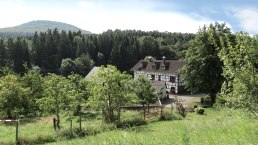
Wanderer beim Aufstieg zum Aremberg, © TI Hocheifel-Nürburgring©Christopher Pfromm,
  • Distance: 9.3 km
  • Duration: 3:15 h
  • Difficulty: easy

Circular short route 9 km | Fürstin-Margaretha-Weg

Antweiler

This family-friendly short version of the Fürstin-Margaretha-Weg offers wonderful views over the Upper Ahr Valley and a fascinating route through beautiful mixed forests in the Ahr Mountains. Small churches and houses of saints line the route. In Eichenbach, the statue in honor of the eloquent tinker Bläke Fritz tells of country life in which hard work was the order of the day, but also humor and a heartfelt faith.
In the dreamy Hocheifel village of Aremberg at the foot of the striking volcanic mountain of the same name, remains of the former fortifications as well as the parish church of St. Nicholas and the Guardian Angel Chapel take you back in time.

Click here for the entire route >> Auf den Spuren der Fürstin Margaretha | On the traces of princess Margaretha


mehr lesen

Marking of the tour:
  • Wegelogo Kurzroute Fürstin-Margaretha-Weg, © TI Hocheifel-Nürburgring
gpx: t800527809_kurzroute 1 (9-3 km

Share content:

Ergebnisse filtern:

Along the route

Katholische Pfarrkirche St. Maximin Antweiler

Kath.Pfarrkirche St.Maximin Antweiler, © TI Hocheifel-Nürburgring,VG Adenau
The church was rebuilt in 1762 in Antweiler. Most recently it was completely renovated and restored in the early seventies for the 1000th anniversary in 1975. Details ansehen

Stone sculpture "Bläke Fritz"

Bläke Fritz  in Eichenbach, © TI Hocheifel-Nürburgring

 Stone sculpture "Bläke Fritz" is a homage to an Eifel original with special humor.

Details ansehen

Restaurant in the Country Inn "Zum Wiesengrund"

Aussenansicht Landgasthaus Zum Wiesengrund, © Landgasthaus "Zum Wiesengrund"
Enjoyment for Body and Soul - Chef Achim Meurer himself cooks here.
Details ansehen

Gästehaus - Cafe`Frank

Cafe`Frank, © Gästehaus - Cafe`Frank
Fresh treats every day Breakfast | Homemade tarts and cakes | Hot meals and snacks | Homemade Chocolates | ice cream Details ansehen
Open map

Bitte akzeptieren Sie den Einsatz aller Cookies, um den Inhalt dieser Seite sehen zu können.

Alle Cookies Freigeben

More information about this route

Start: Aremberg, Burgstraße

Destination: Aremberg, Burgstraße

Distance: 9.3 km

Duration: 3:15 h

Difficulty: easy

Ascent: 264 m

Descent: 264 m

Detailed Map & Tips on the hiking trail

Tourist-Information Hocheifel-Nürburgring

Kirchstraße 15-19
53518 Adenau
Phone: 02691305122
Fax: 02691305196

write e-mail

Plan your journey

per Google Maps

Are you currently spending a vacation in the Eifel or have you spent a vacation in the Eifel in the last 6 months? We would be delighted if you  take part in our guest survey. As a thank you, you can win an Apple iPad.